 Passport


Charles Van Hise's Field Notebooks
02/17/16 | 47m 7s | Rating: TV-G
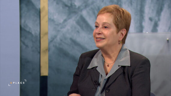
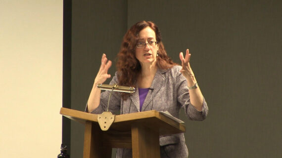
Carol McCartney, Outreach Manager at the Wisconsin Geological and Natural History Survey, focuses on the geological research of the Lake Superior region conducted by Charles Van Hise. McCartney discusses Van Hise’s work, shows samples of rocks and maps, and shares data from his approximately 450 field notebooks. In 2011, Van Hise’s field notebooks were scanned into the UW Digital Collection.
Copy and Paste the Following Code to Embed this Video:
Charles Van Hise's Field Notebooks
Welcome, everyone, to Wednesday Nite @ the Lab. I am Tom Zinnen and I work here at the UW-Madison Biotechnology Center. I also work for UW-Extension Cooperative Extension, and on behalf of those folks and our other co-organizers, Wisconsin Public Television, the Wisconsin Alumni Association, and the UW-Madison Science Alliance, thanks again for coming to Wednesday Nite @ the Lab. We do this every Wednesday night, 50 times a year, and tonight, we are celebrating the end of our 10th year of every Wednesday night, 50 times a year. We started on February 22nd of 2006, (audience laughing) This is the great thing about having a bike accident before you come to school. Wow, what planet are we on? And I'm delighted that for 8 of those 10 years, Wisconsin Public Television has recorded almost every one of those presentations. And I'm particularly grateful to you and all the folks like you that have come to Wednesday Nite @ the Lab over these first 10 years, and the folks that watch at home and online. Tonight it's my pleasure to introduce to you Carol McCartney. She was born in St. Louis, Missouri, and grew up across the river in Belleville, Illinois. She and I are both FIBs. She went to high school at the Academy of Notre Dame, and then went to the University of Colorado to study geology, I think she was inspired by the flat irons. And then she came here to get her Master's and PhD in geology, and she's a glacial geologist, as is the subject of our talk tonight. She has been with the Wisconsin Geological and Natural History Survey since 2009, that survey is part of the UW-Extension Cooperative Extension, so not only are Carol and I both from Illinois, but we both work for UW Extension Cooperative Extension. Tonight, it's about 111 years after Charles Van Hise gave his speech that ended up with a line that I think is the best formulation of the Wisconsin Idea, and that's when he said, "I shall never "be content until the beneficent "influence of the University reaches every family of the state." So it's great to be able to have Charles Van Hise and his work be the topic of the talk tonight for our 10th anniversary. And it's great to have another glacial geologist here. There are three great glacial geologists that I know of. Carol, Charles Van Hise, and Thomas Chamberlin, who was also president of the University of Wisconsin back in the 1890s. So, it's a great pleasure to be able to hear about "Standing on the Shoulders of Giants in the Digital Age," how Carol's been able to digitize notebooks, and some of the mineral samples. Because of this work, that idea of being able to have that beneficent influence of the University reach every family in the state is true in a particularly concrete way, because anybody with a computer anywhere in Wisconsin that's connected to the Internet can now access this great stuff, and I'm very grateful to Carol and her colleagues at UW-Madison that have digitized this. Please join me in welcoming Carol McCartney to Wednesday Nite @ the Lab. (applause) And thank you all for coming, and thanks for letting me be here for your birthday party. I brought along birthday presents for everybody, so if you'd like them, they are pieces of rock this is a piece of red granite, it's the State rock. And there are little baseball cards or informational cards that go with them. So you are welcome to them, they're near the exits on both sides. And the one, having the red granite is particularly appropriate because it's a Precambrian rock, those are the oldest rocks in Wisconsin. And the Precambrian rocks were the subject of this study that Charles Van Hise worked on. And so I'll tell you a little bit more about that. I also want to acknowledge the US Geological Survey, I work for the Wisconsin Geological Survey, and both surveys funded this project, and I've been working on it for the last four years. Maybe five years, going on six, we're very close to wrapping it up and close to getting it online. It's not online yet Tom but it will be soon. The best part about this project really was the collaboration. I got to work with people from the British Geological Survey and lots of people at the Wisconsin Geological Survey, who brought lots of different skills to it, and so, it was a lot of fun and I had an army of interns working on it for me, too, and that was fun too because it's nice to have young people, and they were really devoted to the work. So let me, I'm gonna give you a quick little preview, let's see, there you go. This, so these are, this is the area that was studied by Van Hise and his mentor, Irving, and all of the people that came past beyond them, in the Lake Superior District, Lake Superior Division of the US Geological Survey. So this area of Wisconsin, Minnesota and Ontario, and the UP of Michigan. This is the place that's called the Lake Superior District, and geology is definitely a place-based science. Now I'm gonna see if I can show you. This is, this is how you're gonna get to see when you go online. Researchers and just people who are interested are gonna get to see these images of the thin sections of the rocks, and I'll talk a little bit more about what those thin sections are but this, this is, this is something that I learned how to do from the British Geological Survey, and it makes the rocks kind of come alive, and make them visually appealing. This is one of the thin sections too, and lots of them are just that pretty, and that's just another fine thing about this collection, and so lots of pretty rocks in it. And I'm not ashamed to say I like those pretty rocks. So after the first thousand photos the interns were looking for the pretty ones. And they took 31,000 photos for me, so, we needed a lot of pretty photos. So back to the beginning here, Standing on the Shoulders of Giants in the Digital Age, what am I talking about here? Well, "Standing on the Shoulders of Giants" is the model of Google Scholar, and it's actually a quote from Isaac Newton, who said in a letter, "If I see further than others, it's because I stood on the shoulders of giants." And certainly that's what researchers do. They start with the work done by others in their field, they stand on those shoulders, they learn about what they did, and then they move forward and they move their science forward. Well, that works if you get access to that material. And I also had one of the researchers that works with me tell me that, "Carol, if it's not online, "It doesn't exist." Okay, so, that was one of the first things I heard when I started working at the Geological Survey in 2009, and I made it my mission to get everything I could of our work online. And then I discovered this work that was done by Van Hise and I thought, "Ooh, we gotta get that online, too. "Somehow we gotta get that online." So, and this is what the notebooks look like, you know, if that looks like a ratty old notebook, that's because it's over 100 years old. So the connection to Van Hise made this actually a doable project, and that interconnection to the University and to this collection that we had stashed in our Geological Survey is what made all of this work possible. As you know, as Tom said, Van Hise is the author of the Wisconsin Idea, and he came up with that in 1904, the year after he became the president of the University in 1903. He got his PhD in 1892, and the materials that he worked on that he presented for his PhD were the materials that are in this collection that we're archiving and that we're gonna get online. And he was the Chair of the Geology Department in 1888. Before that he got, so his was the first PhD at the University in 1892. He was the first University president who was a graduate of the University, so a lot of firsts with Charles Van Hise. And he was one of two people that got the first master's degrees, the first graduate degrees at the University in 1882. And he was a protege of Roland Irving, who started the Lake Superior District of the US Geological Survey, where this work was done. So let's get to, the next button, there we go. This is Van Hise Rock, and if you haven't seen it, you can drive to Rock Springs and take a look at it. And it has a plaque on it that explains what the rock is about. But this rock is visited by geology students from all over the Midwest, and some from much farther away than just the Midwest. It's a very important rock. It is actually in place, it looks like it's kind of stuck there as a monument, but it's not, that rock is in place. And Van Hise studied that rock and studied the structural geology of the Baraboo Hills, and figured out a lot of stuff about the geology of Wisconsin, that, back then, that is still very important to our understanding of our State and of the geology here. And there's a tablet there that was presented by the friends of Van Hise at the University in 1923. I won't read it all to you, you can go there and look at it. If you go there, park far away from the rock and walk a block to it, because it's on a dangerous curve. But you have been warned. So as Tom said, the Wisconsin Idea, is attributed to Van Hise is, "I shall never be content until the beneficent "influence of the University reaches every home in the state." And that's very... The Mission Statement of the Wisconsin Geological Survey is very much in line with the Wisconsin Idea. It is our job to study the geology of the state for the people of the state, study their geological problems and find solutions for them, and get that information out to people so that they can make informed decisions. Also one of our, a piece of our mission, and I highlighted it, is to archive this information. And so, that's one reason why we have all these old pieces of rock and old pieces of notebooks and the like, because it is part of our mission to hang on to this stuff and protect it for the next generation. So, the Wisconsin Idea is central to our mission, and archiving is a really big part of our mission as well. This is Science Hall. As I mentioned geology is place-based, I showed you that map. And this is the place where the US Geological Survey started the Lake Superior Division. This doesn't look familiar to you probably because it's the original Science Hall, and it burned down in 1884. The Lake Superior Division was started by Roland Irving in 1882. So two years' worth of work, was, well, the notebooks weren't lost, the rocks were. There was also the Geology Museum in this building and that burned, and some of the big fossils were lost as well. When Tom talks about X marks the spot, this is the X, well, this is the original X, but after it burned down some of the materials that were lost were replaced, for the Lake Superior Division, but, the geology, I think the geology museum just lost quite a bit of stuff of their archive. This is what the new Science Hall looks like, the new Science Hall that you're familiar with. It was built in, let's see, it was built in 1888. And the idea they had when they built this one, it's of masonry and metal, except for the windows and doors and a few of the floors. They wanted it to be fireproof. They weren't gonna have that happen again. It was the home of all the sciences, so the US Geological Survey was there, and later, after 1897, the Wisconsin Geological Survey was there. So for a while there was only a US Geological Survey. And the geology, it was actually called Mineralogy and Geology Department were housed in here. And Roland Irving, who started the USGS division also started the Geology Department. And so that was in 1882. This building, the construction manager had an assistant who was a student, and that student's name was Frank Lloyd Wright. You might have heard of him. I love this stuff, there's so much interesting intertwined stuff. So, this is a picture of Science Hall from, this was on the Web this morning, there's gonna be a special event there next week called Fright Night, and I guess they used to just do this on Halloween, but now that, perhaps it's so popular they're gonna do it in the spring as well. I double-checked, and while it's free, it's almost fully subscribed, at least it was this morning with just a few spaces open. But if you're interested, google "Science Hall Fright Night" and see if you can get in. Because they're gonna give tours of the spooky places in Science Hall. And it's, it's reported to be haunted, and that's because the Anatomy Department was in there, some people there are body parts still in there. But, so, here's a map of the Lake Superior-- produced for the Lake Superior Division, and this map was one of, this was a very prolific group, and you can see the different colors. It's an old map so the colors are somewhat faded, but the things that are not pink are the Precambrian rocks of the midcontinent. And the work done by these geologists defined the Precambrian in the midcontinent and that work still stands today. People are refining it and still doing that kind of work, but why were they out there doing this? Well the 1880s were, that was the decade of invention. And we were, this country was building bridges and railroads, and this work was defined, the iron ranges, and the metallic mineral deposits that were in these Precambrian rocks, so that's why they were doing this work. They produced nine monographs and three bulletins and a professional paper, which were, you know, a really big deal. And they pioneered the methods of, Irving and Van Hise pioneered the methods of petrographic microscopy. And that's something that geologists do. Petrographic, the study of rocks, petrology is the study of rocks. And microscopy is using a microscope to do that. So they really pioneered this work, the kind of work that geologists are still doing today, looking down microscopes, looking at rocks and thin sections, and what a thin section is, they carve a piece, a little skinny piece off the rock, with a diamond saw, and then they grind it down until light will pass through it. So it's so thin that light will go through it. And then they shine polarized light through it, and they cross with another piece of polarized film, and then looking, that's how they can, using the optics of those minerals, they can tell what the minerals are, and how they formed, and how they were deformed in the history of that rock. So, it's an important way for geologists to study rocks now, and these guys on this collection really pioneered that work. So when they did this work, they went around, this is what geologists do today. They go around and they collect rocks. These are called hand samples. They're called hand samples because, it's kind of hard to tell from this picture, but they're about the size of my fist. They fit in your hand, that's what a hand sample is. This is geology, it's not rocket science. (laughing) They collected 80,600 hand samples in the years that the Lake Superior Division, that was between 1888 and 1922. We have only 9,800 of those rocks, so quite a few of them were lost. Some of them were lost during the fire that I mentioned. And then, after 1922, when the Lake Superior Division closed up shop, they shipped all of their paperwork and files and the like to western Virginia where the US Geological Survey is. And they, they left the rocks behind and they went into storage. And some of them went into storage into a basement of a building that was later demolished. Well as it was about to be demolished, some geologists found out about it, and they rescued some of those rocks. And so I think some of them probably were destroyed in the demolition, but a lot of them were rescued, and then farmed out to the University of Wisconsin- Oshkosh and their teaching collection. I know there's some there. And I know there's some at the University of Wisconsin Milwaukee in their teaching collection. So I think what we're doing is gonna make their teaching collections more useful, because a rock like this, well, if you don't know where it was collected, you don't know what it was described, even, you know, have no context, no provenance, what you have is a paperweight. But if you have all that other information, then the rock is data. And so we wanna turn all the rocks into data. And so all of our, we had all the, what was left of the rocks, and everything was sent to western Virginia, but in 1981, a geologist in Reston, Virginia sent all of the papers back to us. He actually sent us 36 cartons of field notebooks and lab notebooks and maps, and thin, he sent the thin sections then which are those little bits of rock. And, he said in his letter that accompanied it that we'd be doing a great service if we could reassemble the notes and thin sections and rock samples into a single collection. Which we did. And we archived them, because in 1981, that was pretty much all we could do is put them away and so that's what we did. But in 2009, the UW Digital Collection took an interest in us, and this, thanks to Marie Dvorzak who is the librarian in the Geology Department. She introduced the Digital Collection people to us, and, they, so this is our page on the UW Digital Collections website. And at the bottom, you can see a bunch of icons. There are lots of pictures. In 2009, they got interested in scanning our photographs. They're historic photographs of Wisconsin geologists doing their field work from about 1918 to the mid-1950s, maybe that late. So there, there were over 5,000 of them, and Library Science students came to our office and scanned them, and built a database, and so they're online. If you'd like to look at old photos of geologists, this is a great source of them. And then after they got started doing that, they scanned our bulletins. And so on the far left side, our bulletins are all available. They're online and available, as I mentioned, it was my job to get everything online at the Survey. So you can see them on our website, but you can also see them here. And, in 2011, the Digital Collections got interested in the Van Hise notebooks, because of his importance at the University. And so, they, the Lake Superior notebooks, they took all the notebooks that were signed by Charles Van Hise, ones that he had written, and they scanned all of those. And then we looked at those and we said, "Wow, "Those 60 notebooks are only... we have another 400." So we went looking for funds to get the rest of them online. And so that's, we're in the midst of that project of getting the rest of those notebooks online. We've already invested $130,000 of our money and $130,000 of the US Geological Survey's money to work on this project, to get these things online, and to compile a database that makes them really accessible. This is what the notebooks look like. I've blown it up about the best I can do. And they don't look much better than that. This one says US Geological Survey Field Notebook Number 6, August 1883, I think that's a 3, yeah, I think so. And it says Original Huronian and Spurr, Michigammi, Champion, and Republic. Those are mine names. They were mines in the Upper Peninsula, iron mines. And so, and then it is signed by C.R. Van Hise. And then there is, in red, there's some numbers that are the samples. They identify the rock samples that were collected and written about inside this notebook. This is, I just wanted you to see kind of the bindings of some of these notebooks. Some of them look pretty good, but a lot of them look like they're about to fall apart. And this is pretty typical. So they're on brittle paper and they're about to fall apart. The ones that are in good shape are in good shape because they were in a drawer for 100 years, and hardly anybody took them out. And so we've taken them out and taken their pictures and we are anxious to get them all put back in the drawer. But now people can see what's in them without having to open them up again. And this is what they look like on the inside. They're, normally, but not always, but on the left hand side there'd be a hand drawn map, and the hand drawn map does show where the samples were taken. So there are little numbers written along these drawn outcrops, and then they are also numbers on the right hand page in the left column, those numbers are the sample numbers too, and then they're described, the township and range and section where they took the samples as well as just what the rock represents, what the original geologist thought they were looking at. And so this information is, you know, in the notebooks, and as we were getting them scanned, we realized, "Wow, we've got all of these samples "and all of these locations, but we need to relate them all." And then we had all these thin sections that we had an idea what samples they were from, but we didn't know how to find those numbers in the books. So we started developing a database that you can query to find, you know, if you're interested in an area, you can go to an area. If you're interested in Van Hise you can go to Van Hise and find his rocks. And so, now, we've extracted all the data that we can from these notebooks, and populated this database. And to date, we've scanned about 60% of the notebooks. And so that last part of the notebooks and the last 40% still needs to be scanned. And, oh, we're not going to scan all of them. And that's because, I mentioned that Van Hise was the protege of Roland Irving, and C. K. Leith, for whom the geology library is named, was the protege of Van Hise. He wrote all of his notes in shorthand. And what's more, it's a shorthand that was reported to have been only decipherable by Leith and his secretary. (laughing) Now, it was, it was supposedly a standard shorthand, but it was sort of a dialect of that standard shorthand. And so, we think that there's really no point in taking and scanning those. So we have pulled those out. But anyway, that, yeah. But we do propose to finish these next things in the next fiscal year. This is what one of the thin sections looks like, this is just a plain photograph of it, taken with, actually, I think... my phone. But you can see that it looks, it does look old. They don't all look this bad. What it says on the top is, it's difficult to read but it says "Precambrian rocks of NW," which I presume is Northern Wisconsin. And it has a Collection Number, Number 631, which is, we have interpreted, we figured out that it's, that's the rock that it was cut off of, that's the hand sample it came from. And then it has a thin section number so that's 163 on this one. It's a regular photo, and you can see how yellowed it is. So thin section, I think they still use Canada balsam but I'm not sure, but that's the glue. So when they make that very thin piece of rock, they glue it then to a glass slide and grind it down until they can get light through it. But it's glued down. And then they put just a little bit more glue and, they put a... -
Voiceover
Cover slip? -
Carol
Yes, cover slip. That's what I was looking for, thank you. A cover slip, so you can see the outline of the slide and the outline of the cover slip, and you can see that that Canada balsam is definitely degrading, it's alligatoring, and, when it turns yellow, it's messing with the optical properties of this thing as well, so you see something different than what the original geologists saw. So when we saw this in about a third of the thin sections that we have, we thought we need to do something to rescue these, you know, it's kind of ashes to ashes, dust to dust, they're falling apart. So we thought we would rescue them by taking their picture. At least we can, at one point in time, get a picture of what it looked like and, make a catalog of those photographs for geologists and, mineral explorers or whoever wants to look at them, they can see them. So, nope, not there, there. Alright. I just wanted to show you some of the pretty maps too. Sometimes the maps were colored, but it still has little, little samples on it, and, as I mentioned, what we really wanted to figure out was where did these rocks come from? Because rocks without locations are paperweights. And this is what the structure of our database looks like. So we based everything on where did that rock come from? And then are there, you know, where's the sample location? What other information do we have about it? Does it have a thin section? We have, as I mentioned, about 10,000 of the rocks, almost 10,000 of the rocks. We have 15,400 of the thin sections. And some rocks had no thin sections, and some rocks had up to three. So it was a real jumble to try to figure out. As soon as we figured that out, we said, okay, we definitely need a database to sort this out, and to make it clear. But now we can go in, we have the database up and running, we can look in the database and find things by location, we can find the location in the notebooks where that one example was discussed. So you could look at a location in the UP and find out who wrote about it and on what page, and then go look at that page on the Digital Collection. So it is accessible, but what we really wanna do is get those pretty pictures online. So as I said, you can go to a location, and those locations are, there were samples taken in Ontario, and Ontario doesn't have the township and range location system that we have. And so all of the locations of the samples in Ontario are like along Lake Gitche Gumee or, you know, 20 miles out of this town. And so we don't have those, we can't locate those on a map. Because we could turn the township and range locations into lat/long and plot them up here, but we can't do that with Ontario. So if you're interested in the locations of Ontario, it's gonna be a bit more of a slog and a dig. But we do, we did concentrate on getting Wisconsin, Minnesota, and UP located. Again, this is, when you get up close, this is what the notebooks look like, and this is where we extracted all of that data. Now this is not one of our thin sections actually, this is a thin section from the British Geological Survey. So while we were working on this project, because what we were doing was building a database and extracting the information and trying to relate the, make these paperweights into data. And at the same time, the British Geological Survey was photographing their thin sections and putting them online, and I saw this on a blog, and I thought, "Wow, 100,000 thin sections, hmm." And then the next day, or a week later I saw, "Ooh, they did 250,000 in a year." Oh come on! Well, certainly, we could do our 15,000 if they did 250,000, couldn't we? So that's what gave me the idea to do this. And I did contact the British Geological Survey, and I said, "So, how did you do that?" And they, I was, you know, expecting to hear back in a day or two, I mean, there's a time difference for heaven sakes. The Brits that were doing this were in Scotland. I heard back right away. And they were anxious to explain how they did it, and give me information, and help me figure out how to do it here. This is what they did, and they sent me this picture of their apparatus for taking pictures. And as I read the blog, one of the volunteers said that they were pretty sure that the reason they had the fancy cross-polar pictures was just to keep them interested, because it got a little tedious. I'm sure it did. This is what we did, so this is one of my interns. Now, the thin sections that we have had been in a drawer for a long time, or you know, they might have actually been stored on a radiator, some of them looked so bad. But they all had 120 years of dirt on them. And so this is someone cleaning. So one of my interns, we developed a procedure for how you would clean it without damaging the label, because those labels are part of the historic artifact, if you will, and so, we cleaned them, and they had to be washed with soapy water. The only way we could get all the dirt off of them was to wash them with soapy water, rinse them with deionized water, and dry them with a tissue. They didn't air dry very well, they looked terrible. So all 15,400 were washed and dried by the four interns that work on this project. Luckily they all enjoyed each other's company, and they went into the lab, they turned on the music, and just, you know, worked away at it. And there's a computer there, because while they were doing the work in cleaning them they were also QA'ing, doing quality assurance work on our database that related the thin section to the hand sample, because this was the first time that we picked up each one of the thin sections and looked at the number that was on it. We had been getting the numbers out of the notebooks, and so this was kind of our last chance to figure out if we had the numbers right. And if we didn't, they made notes, and our archivist would then go back into the notebooks and figure out if, you know, if we'd made a mistake in the database. Most of the time that's what happened, but every once in a while, we'd find a mislabeled slide. And so, so anyway first we washed them all, and then we started taking their pictures. This is what our apparatus looks like to take the pictures. And one of the geologists at the Wisconsin Geological Survey built this wooden thing in his shop. At the bottom, the... at the top is the camera and it has a macro lens, and it's shining down through a piece of polarized film, kind of like you know, when you put on your polarized sunglasses, it changes the light. And then, it's shining down to the thin sections that are on the next tray down. And, I wonder if I can, can I point at that? No, I don't think this works. So the thin section is on the next tray down, and beneath that is a light. That tray is made of a piece of Polaroid film too. So we have the thin sections on a piece of Polaroid film going this way, and the upper Polaroid film is going that way, so, that's what they call crossing the polars, and things look different that way. So we take one picture without that upper, and then we slide it in and take the second picture. So of the 15,400 we had almost 31,000 photographs we took. God bless those interns, they did a great job! And this is, this is one of them at work, taking the pictures. And, we would look at the picture on the computer screen, and then take the photo, label it, change the polarity, and take the next photo. And I sent the pictures of our apparatus to the British Geological Survey, just to say, "Well this is what we did, you know. "This is what we're gonna do now, "we're still kind of working the bugs out "to get it to something that would just be streamlined." And he wrote back and said, "Wow, that's really great. "That's, you know, I like what you're doing. "Oh, by the way, "I see that the slide in the background "is dark blue instead of black, "and of course if you've got the polars crossed, "it should be black. But this is what you can do, post processing." And so, even, you know, even you know just going on without my requesting it, he was collaborating with me and helping me with my project. So, God bless Bob McIntosh. So this is looking down just what, you know, it looks like when we're taking the photographs. And this is what our first photograph looked like. And, so it, it might look a little blurry to you, everything looks a little blurry to me at this time of day, but it looks a little bit blurry, and that's because... and actually I had one of the geologists, Phil Brown from the Geoscience Department came over to look at it because, we wanted, before we really got into production, I wanted to get, you know, a geologist who does this to look what we're doing and see if we were headed in the right direction, if we had some huge systematic error. And the first thing he said was, "What the hell is this? "Get me a petrographic microscope. "oh, my God, what are we looking at?" I'm like, "Settle down, Phil." (laughing) It turned out that he decided, and of course he was right, but, it wasn't, it's not completely flat. And thin sections have to be ground to be completely flat. But this was one of the very first thin sections that Irving and Van Hise made, and they were working that out, working out how flat and how thin things needed to be. So that's why it looks a little bumply, and in fact, some of those really cool colors are due to the fact that it's not as thin as it ought to be, it should be just totally clear, but, but remember, they were making up the specifications. This isn't to specifications, because they were making it up as they went along. And this is one in plain polar light, and I included that just because I think it's lovely. So I think that, and the geologists will look at that and say "Oh, there's orthoclase, and I see there's this. Oh, yep," and so that's, but this isn't exactly microscopy. We're not looking down a microscope, we're looking through a macro lens, so it's not nearly the magnification that they get in a microscope. Which is one of the criticisms that Phil had of what we were doing, but, so we're not really doing science, what we're doing is creating a catalog, so that scientists can look at it and see a little bit more about what we have than just the basic description. And then they can see if they really wanna come see the rest. This is what a lot of them look like in plain polar light. On the right hand side you can barely see, but there is a label, we always photograph the label, even though the file name had the label number in it. But that was another way for us, we went back and did quality assurance on all of them to make sure that the file names matched the labels, and we didn't want to lose that label. It's prettier if you crop out the label, but... This is what it looks like in cross polar, so, it's a much prettier sample and that kind of keeps us interested. And this one, you've seen this one before though because I showed it to you earlier, because this is what it looks like when you cross the polar, so, I see what they mean at the British Geological Survey that it's more interesting, and maybe that's why we have them in there. So you can see. But what the geologists see and what they use to identify the minerals is not just what it looks like in plain but how different it looks like in the crossed. And when you go between the plain and the crossed, what happens? And so what we did was we took these photographs, they're aligned perfectly, so, we took both photographs, the only thing we moved was the polarizing film, we didn't move the slide. And so you can overlay those individual photos and so we can put them online, and fade from the plain to the cross polar so it looks like you're turning the stage, it looks like you're doing what geologists do. It's maybe a little sleight of hand, but it really makes the whole collection more appealing and I think it does show researchers what they might be looking for, and might get to see, if they came, you know, came to actually see, and they could go online and see if they wanted to come look at our collection. So this is another one, and it's beautiful pair, which is so much prettier. And so we've created these thin section pairs for all 15,400. So we had the pair photos, and, and they're, they are zoomable, that is you can, they're a high enough resolution that you can zoom in. And because they overlap, they can, you can, scale between the plain and the crossed, and, and this is where they're all located, our collection. Now you can see that not a lot of them are in Wisconsin. And you might wonder why are there so many more. Of course, you know that there's been more iron mining in the UP than in Wisconsin, although in Hurley there was iron mining in Wisconsin, it's not that we haven't had any. But, and there's a lot more in Minnesota. And the reason for that is the glacial geology, the part that I'm quite fond of. There's a lot more glacial cover in Wisconsin than there is in UP, and a lot more glacial cover than there is in that part of Minnesota. And you can see the bulk of those samples are along the shore of Lake Superior. So the mineral deposits in Wisconsin were not, were not really found, not very much discovered until the 1970s, when geologists were able to pull their instruments behind the airplanes and fly across the state. And that's how they found the mineral deposits that you may have heard of the Crandon deposit, that was in northwestern Wisconsin. And, so, those techniques allowed geologists to look through the glacial materials. So the glacial materials, which some of the geologists refer to as overburden, we don't, we don't do that. But we don't call the things underneath underburden either, that's not nice. So you can see right through it with these techniques. Let's see, now. Now we're going to look at, so that map that I showed you, what we plan to have is the database online that has a user interface that you can search. But also each of those dots will be what I call a smart dot, that is, you can click on it, and it will tell you what that sample is and what other information we have just by clicking on it. So it could take you to the database, and it could take you to the photographs if they exist. So you'll be able to, and geologists wanna look at a map, and I think we're all getting kind of trained by Google Maps, let's just look at this on a map, so, we're hoping to have this user interface that makes it easy for people to see where these things are, and then where the data is behind each one of those dots. And this is one way that we might be able to show, see I can do this. Alright so, this is a very early iteration we're working on this, but it still gives you an idea of what a geologist might be able to do at his desk instead of having to look down a, no, go back, yes. I did that myself, without turning it off, I'm so proud. Alright, here we go. So, now, this is a video of zooming in and moving around, looking at, and that's what geologists do, they'll move around and look at individual minerals, and then cross the polars and see what happens when it goes and if it goes to extinction, that is it goes black when it's completely crossed. I know that that one's quartz. There's not much I know about optical mineralogy being a glacial geologist but I know that part. So those black things are quartz, and of course, the black on the outside is quartz because that's the glass slide, so. That's pretty much that part. So here, am I on the next one? Yes, so we extracted all of the data from all of the notebooks, and we're in the process of getting the notebooks all scanned. They're all, what has been scanned is all ready on the UW Digital Collections, so you can go look at it, you can open up your computer and look at it tonight if you'd like. We can see the notebooks written by Charles Van Hise. And if you come to our office you can see our database and look through. But we're gonna work on a much more user-friendly user interface that includes that map. And, of course, you can see these maps already because these are the maps that are in the notebooks, and they're already on the Digital Collection. But they're even, this is a cross section which geologists love, so... This is a syncline, the rock layers bent, and it shows where they sampled. The numbers on the left and the numbers on the right are where the samples were taken from. And the picture on the right shows the detail that you'll be able to see when the images are fully zoomed. So, while it isn't the zooming-in you can do with a microscope, it's a pretty nice approximation for a catalog. And, the title of, we have a data-preservation plan, a long range plan for data preservation for our archiving at the Wisconsin Geological Survey, and the title of it is "From Acquisition to Access." And so we have, thankfully, the US Geological Survey allowed us to acquire all of these materials that are about our region. And so it's important that we have them, and by the people that are important to us, Irving and Van Hise and Leith. These are names that we see on buildings and around here, that are important to geologists in this area. And so we've acquired this, and we are about to get access to as many people that can on the Internet, and so I'm pretty excited about that, because as the Outreach Manager at the Wisconsin Geological Survey, access to our materials is fundamentally my goal and my job. So, let's see. And now, what we're gonna do is we're going to, the last step in this, after we get the last of them scanned and the database online with this wonderful map and all the beautiful pictures, the last thing we will do is to wrap these things back up, and put them away, archive them again, so we can protect them for the next generation, when there are newer methods, and newer ideas about how we should look at these things. And that's it. (applause)
Search University Place Episodes
Related Stories from PBS Wisconsin's Blog


Donate to sign up. Activate and sign in to Passport. It's that easy to help PBS Wisconsin serve your community through media that educates, inspires, and entertains.
Make your membership gift today
Only for new users: Activate Passport using your code or email address
Already a member?
Look up my account
Need some help? Go to FAQ or visit PBS Passport Help
Need help accessing PBS Wisconsin anywhere?

Online Access | Platform & Device Access | Cable or Satellite Access | Over-The-Air Access
Visit Access Guide
Need help accessing PBS Wisconsin anywhere?
Visit Our
Live TV Access Guide
Online AccessPlatform & Device Access
Cable or Satellite Access
Over-The-Air Access
Visit Access Guide


Follow Us