Tracking Glaciers Along The Edges Of The Driftless Area
Sediments left behind from the edges of the retreating ice sheets are providing geologists with a unique opportunity to better determine when the glaciers covered Wisconsin's Driftless Area.
By Donna Crane
March 15, 2018

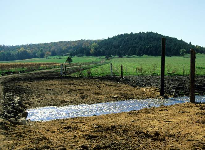
1997 restoration of Black Earth Creek in western Dane County

About two and a half million years ago as the Quaternary glaciation commenced, enormous ice sheets slowly made their way into northern areas of what’s now the United States. Over the multiple advances and retreats of these glaciers, they left behind geological debris called drift. Yet, as glaciers flowed into what is now the Upper Midwest, one section of the landscape was left untouched.
The expanse of land that glaciers did not cover is known as the Driftless Area. The region, centered on a portion of the upper Mississippi River valley, includes stretches of southwestern Wisconsin, southeastern Minnesota, northeastern Iowa and northwestern Illinois. The sediments left behind from the edges of the retreating ice sheets are providing geologists with a unique opportunity to better determine when the glaciers covered the surrounding areas.
Eric Carson, a geologist with the Wisconsin Geological and Natural History Survey and and assistant professor in the University of Wisconsin-Extension Department of Environmental Sciences, has studied glacial deposits around the Driftless Area to determine how long ago the ice sheets retreated. He discussed this work in a talk for the Wednesday Nite @ the Lab lecture series on the UW-Madison campus on March 28, 2012, which was recorded for Wisconsin Public Television’s University Place.
The research approach used by Carson and his team include drilling into the earth, gathering core samples and determining the age of these materials using radiocarbon dating and optically stimulated luminescence, also called OSL. Radiocarbon dating focuses on the age of the organic materials in a sample, while OSL is used in cases when there are little or no organic materials. This latter method measures the number of years that a grain of sand has been buried away from the sun.
Carson shared the results of radiocarbon tests conducted on organic materials found near Baraboo in eastern Sauk County and two sites near Black Earth Creek in western Dane County: Marsh Valley and Swamp Lovers Valley. Grains of sand from the same locations were tested using the OSL dating process and a statistically consistent time frame was determined in all three locations.
Carson also discussed testing the viability of using OSL as a means of determining when glaciers were present in areas where organic materials have not been found.
Key facts
- There have been three major episodes of glaciations during the Quaternary geological period: Pre-Illinoian, which started about 2.5 million years ago and extended to about 500,000 years ago; Illinoian, from around 300,000 to 130,000 years ago; and Wisconsinan, the most recent period, occurring from about 100,000 to 11,700 years ago.
- Mineral grains, particularly quartz, tend to accumulate electrons in their crystal lattice that are released by the decay of surrounding radioactive elements. This phenomenon is the basis of the optically stimulated luminescence dating method. Measuring the amount of electrons that have accumulated in a grain of sand provides an indication of how long it was buried.
- The most common minerals emitting radioactive elements in sand bars or buried in dunes include thorium, potassium and uranium.The radioactivity of these elements in the surrounding sediment must be determined in order to date the sand.
- Grains of sand begin to accumulate electrons from surrounding radioactive elements after being buried for about 300 years, and become saturated with electrons at about 100,00 years. This time frame defines when OSL dating is useful.
- Radiocarbon dating has a statistical error rate of plus or minus 60 years
- Optically stimulated luminescence dating has a statistical error rate of plus or minus 10 percent.
Key quotes
- On the challenges of dating the exact time of the glaciers: “We can tell from the geomorphology, from the landscape and the landforms that are posited, we can tell where the ice was. We just don’t have the ability to pin down an exact time for when the ice was there.”
- On radiocarbon dating: “If you’re interested in the migration of plant species in the landscape, it certainly helps if you can know when advances and retreats were occurring, and in a very detailed sense.”
- On the limitations of radiocarbon dating: “The permafrost conditions limit the amount of material you’re going to have. So there very often isn’t a whole lot of radiocarbon material, datable material that extends back to the maximum ice conditions.”
- On the life cycle of a grain of sand: “What we know is that short exposure to direct sunlight, something on the order of 15 to 20 seconds of exposure of a sand grain to direct sunlight, will flush its crystal lattice clean. So this is interesting if you think of the life cycle of a sand grain that it can be buried and exhumed and transported and buried and exhumed and transported multiple times over.”
- On the creation of Marsh Valley and Swamp Lovers Valley along the course of Black Earth Creek: “Because ice was in the headwaters of those valleys, water was coming down and outwash was coming down those valleys, and the outwash was actually being deposited on top of those lake sediments. And then as soon as ice began to retreat, as soon as it back off no more than a mile or so, it got out of Marsh Valley, it got out of Swamp Lovers Valley and the supply of outwash down these valleys was cut off. But there was still outwash coming down Black Earth Creek, there was still outwash coming down the Wisconsin River, so they continued to aggrade. They continued to fill up with outwash. And so once ice began to retreat, lakes were reestablished in those two valleys.”
- On the organic material found in the Swamp Lovers site: “We found abundant and diverse assemblages of pollen, of phytolith — which are plant remains — and also of diatoms, which are algae that lived in the water column. …All of those are very nice for us because they give us indications about the climate, the water conditions, the water temperature, the salinity.”
- On their findings at the Swamp Lovers site: “And this, over and above everything we were originally looking for, which we whether we’d have good sediment for an OSL date, which sure enough we have. …This is ideal for us if we’re interested in accuracy and precision.”
 Passport


Follow Us