


PBS Wisconsin Passport
Watch this video with
PBS Wisconsin Passport
Become a member of PBS Wisconsin, support your local community, and get extended access to PBS shows, films, and specials, like this one.
Arizona Volcanoes
10/18/21 | 26m 46s | Rating: TV-G
Arizona is not known for its active volcanoes, but its landscape is dominated by the products of millions of years of volcanic explosions. And the plumbing that funnels molten lava to the surface is still intact and waiting for the opportunity to erupt. The last explosion occurred around the time Normans were invading England and it could recur at any time.
Copy and Paste the Following Code to Embed this Video:
Arizona Volcanoes
(birds chirping) -
David
Volcanoes are found everywhere in the Americas. And my home state of Arizona, is no different. Some of Arizona's volcanoes are quite young. Some, are less than a thousand years old. They are part of the Great Colorado Plateau. And, the Grand Canyon. (boat engine roaring) (group hollering) (gentle ambient music) -
Narrator
Funding for "In the Americas with David Yetman" was provided by Agnese Haury. Funding for "In the Americas with David Yetman" was also provided by the Guilford Fund. (theme music) (inaudible) -
David
Volcanoes have shaped the landscape of almost all of the Americas. From Tierra del Fuego in the South, to the Great Alaska Range up in the very North. Volcanoes are everywhere. In some places, where you wouldn't even expect to find them. But as we move around the Americas, and see the variety of them, we realize that we live in a landscape that is subject to change. (guitar music) In Southern Chile, we have filmed in the town of Pucon. At the far Eastern end of Lake Villarrica. It's at the base of Volcano Villarrica. At its summit, is a lava lake, that is constantly issuing steam and ash. It is so active and volatile. That residents of Pucon routinely practice evacuation. And the city officials have painted a green stripe on all the roadways with arrows telling, "This is the way out of town, if there's an eruption." Farther North in Chile, we find the now dormant Volcano Osorno. Which is a national park. It's huge, and at any time it could also erupt. Farther North yet in Ecuador, we have ridden horses around the base of the Volcano Cotopaxi. The world's highest volcanic mountain. It has erupted repeatedly in the last 200 years. A different part of Ecuador is the Galapagos Islands. Which are not part of the Great Rim of Fire. They are what's called a hotspot. In the Nazca Tectonic Plate off the Coast of South America, magma has worked its way through the surface, in a specific place. And as the plate moves Northeast, and burrows under South America, the hotspot stays in one place. The volcanic action is moving to the Southwest. And as we climb up the huge crater, on the island of Isabela, we can look down upon this former lake of lava. In the year 2020, it filled up again. As we move North, it's back to the Rim of Fire. We move through Ecuador, through Columbia, where volcanoes have in recent years killed thousands and thousands of people. Into Central America and especially Nicaragua and Guatemala. In Nicaragua, we drove up to the rim of the restless volcano called Masaya. We were fortunate to find the road open. It is often closed, because of the danger of eruption. And the clouds of toxic gases that are spewing from its enormous crater. That's a yawning abyss that you can look down into from the top. And see the levels of lava that have built up over the centuries. It's the most dramatic volcanic abyss in the Americas. (soft flute music) In Guatemala, we spoke with people in the small village of San Miguel Los Lotes. It was destroyed in 2018 by a pyroclastic flow from the volcano called Volcn de Fuego. It killed more than 200 people. (indistinct foreign language) -
Woman
It was 2
30 in the afternoon on Sunday, June 3rd. When the volcano had been rumbling for three days. That morning, every boom would make the house shake. (indistinct foreign language) In only five minutes, ten minutes. As you see here, this is how the community ended. My family and I fled. My feet were burned. But many people died. Children, young people, elderly people, women. A lot of people in this alley died because they were trying to escape. -
David
It was 2
Moving into Mexico. We still see the evidence of the Rim of Fire. The Volcanoes Popocatpetl and its sister Iztaccihuatl. Popo is a constant threat to hundreds of towns and cities. Those volcanoes are terribly destructive, but ultimately the volcanic ash and other volcanic products enrich the soil. If you go around the world, to tropical places where there have been active volcanoes, you will find that they are densely inhabited by farmers who find that soil very, very rich. (bright upbeat music) Moving North along the Mexican coast, we find volcanoes such as the Pinacate Volcanic Field. Located partially, in the United States. It has massive craters and lava flows. That show it is an active field. -
Man
It was 2
There were explosions and there was hydrothermal activity. And there was lots of water, steam. Magma contacted the mud and the water table. -
David
It was 2
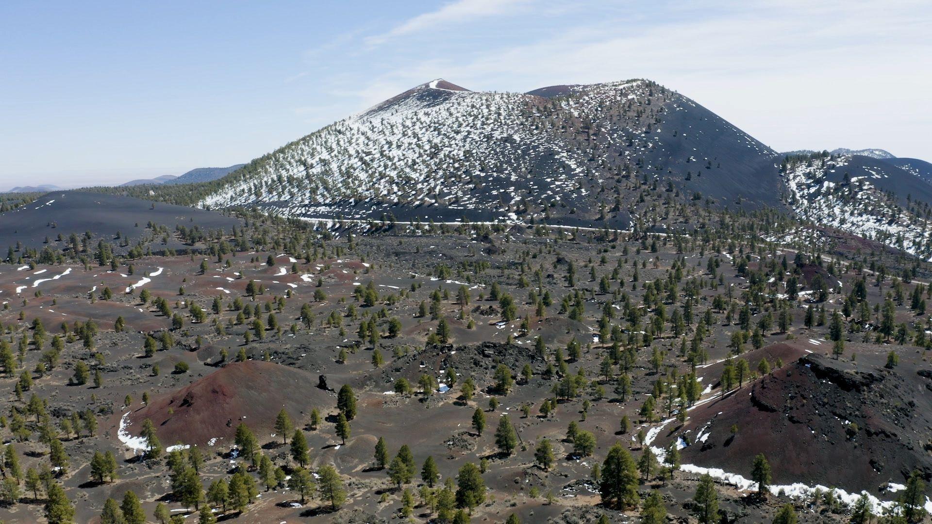
In the US, we visited the Cascades Range. Part of the Rim of Fire. In Oregon, huge mountains of lava remain. And Newberry Crater still has a flow of nearly pure obsidian. And a chamber of liquid lava, lurking beneath the volcano. The Cascade Mountains extend into Canada. But for variety, nothing can match Alaska's Volcanoes. More than a hundred of them. Wrangell Mountain, St. Elias National Park, is home to active volcanoes called shield volcanoes. That have built up thousands and thousands of feet for NAVA, leaving a legacy of powerful organism. The Alaska Range is volcanic in it's origin. Mountain Redoubt at the Eastern end of the Aleutian Peninsula, is alive. It is steamy. It is spewing. Lava is building in a massive dome, that could erupt at any time. So we see that the Pacific Coast of the Americas, is a place alive with volcanoes. But, in the Southwest, there are other kinds of volcanoes. And one of them is among the youngest in the country. It's part of the San Francisco Volcanic Field. Arizona has a lot of volcanoes, old volcanoes. Some, 70 million years old. Some, 28 million years old. Some, 10 million years old. But we also have a volcano, that erupted about the time that the Normans were conquering England. (guitar music) The Vermilion Cliffs in Northern Arizona, give a very good portrayal of the nature, of the Colorado Plateau. It is an area more than 30,000 square miles of vast layers of sedimentary rock laid on top of each other. Thousands and thousands of feet thick, and is a very stable part of the Western United States. If you want to see a volcano, you have to look for one of two things has happened in the Colorado Plateau. Either there is a place where a hotspot, a place where magma pushes up and has a great deal of force. Can push its way through. Such as the San Francisco Peaks. Or, the earth is tearing itself apart and pulling off pieces. And Magma can walk itself through. Fortunately for us, we can see both. Merriam Crater is right at the Eastern end. Here we are, the whole volcanic field. And there's lava here behind us. The lava flow is heading way out there. And then you see the red, and the colors of the rest of the Colorado plateau. But then the lava. -
Dick
It was 2
Well, what's great about this spot is, we see these multiple lava flows. It came off and ultimately they joined together and dammed up the little Colorado. And created the Grand Falls, 20,000 years ago. -
David
It was 2
And you can't see the falls, but you can see them heading that way. Imagine how much lava it takes to make six miles in the lava flow. Geologists go nuts here, because it's a live field. It's a laboratory. It's a laboratory of volcanic cinder cones and lava flows. Went on for miles and miles, until it finally reached the little Colorado River. And it's interesting, because there it ends. The Eastern edge of the field is the youngest part. To take a tennis ball and tape it to the floor, and then put a throw rug over it and drag the rug slowly representing the North American Plate. And everywhere across that tennis ball, is the continuing hotspot. We're above the tennis ball right now. As the plate keeps moving. -
David
It was 2
And someday, there will be more volcanoes coming out in that direction. The ones that way, are either dying or dead. They are not extinct, but I believe they'll never, erupt again. And we are gonna have more to the East. (guitar playing) -
David
It was 2
You know The San Francisco Peaks, are the one mountain in Arizona. You can see from what, a hundred miles away? -
Dick
It was 2
Sometimes it's more than that. How many volcanoes are in the field? Well, over 600, mostly cinder cones in the San Francisco volcanic field. But this is the big one. -
Dick
It was 2
This is the Kahuna. If you follow the slopes, it goes now from 12,600 up to 16,000 originally. -
David
It was 2
What happened to the other 4,000 feet? -
Dick
It was 2
Well, it may have blown off. It may have collapsed, and been washed away. Nobody really knows for sure. The farther away you get, the more easy it is to visualize the mountain foot, you look at what we have. (David chuckles) -
David
It was 2
Then, the next thing going where the hotspot travels Eastward as the plate moves West, is Sunset Crater. -
David
It was 2
It was an explosive event, that put out so much taper, so much crud, that it was more or equal to what came out of Mount Saint Helens. Which is just hard to believe. A little grime of snow all the way around actually shows what the top of the crater is. -
David
It was 2
When do the lava flows start? -
Dick
It was 2
Typically, with cinder cones, if there are lava flows associated with it, they come toward the end of its life. That one is the main thrust of the cinder cone is to build up, build cinders, throw stuff out the top. And in this case explode, and then the lava comes out the base, as like the last dying gas. -
David
It was 2
I have heard about rafts and lava flow. -
Dick
It was 2
Well, rafts basically are parts of a solidified flow that are picked up by lava and carried. -
David
It was 2
So it looks as through the flow once you can see it moving, versus a ship on top of it. It's ejected. (indistinct) Like these big chunks here. Those are rafts that were brought off the original cinder cone, which is way up there. -
David
It was 2
So it could be miles away. These are just floating out on top of it. -
Dick
It was 2
Exactly. This is an older flow and that lava over there just came and literally just pushed it out of the way as if it was made out of cork. -
David
It was 2
Pinnacles' shapes and leaves are something out of the Lord of the Rings. Look there are gobblins right there. -
Dick
It was 2
No that's a hog. That's a hog gobble. (David chuckles) (slow instrumental music) -
David
It was 2
At the Northeast corner, of the San Francisco volcanic field is probably the best known of all of the lava flows and craters is called, The SP Crater. The flow itself goes several miles out, but how it occurred is especially dramatic. Because at the dying time of the SP Crater, it broke through the edge, and carried huge amounts of lava and a lot of rock with it. Way, way out into the plains. And we can see this today, and try to imagine it glowing red, with huge amounts of fire jumping up here and there. And the lava creeping along very slowly, incinerating everything in its path. -
Dick
It was 2
The life of a cinder cone is gotta be short lived. Maybe, a hundred years max. The Stromboli effective volcanoes where stuff comes out of the top, would have a great effect on people because it affected the atmosphere. But in this case, once that was over it may have been a long time before these lava flow started. A volcanic flow like this can conceivably move three or four feet per second. Typically they creep. So you see pictures nowadays of people getting up to all the flows, taking pictures of it, and then backing off because of the heat. Look into the East from Merriam Crater now, we can see that there are a few spotted small cinder cones out there. Which are actually in the zone of the new creation area for volcanoes as they come. Originally, when the lava first came down here, it was just a river of lava. But as the lava cooled, the outsides cooled first, the middle of it would stay wet or moist and continue to push. And eventually it would build up sides. And right here on the, you can see in this left side here. This rampart, it was pushed up as that lava came down like a bulldozer, and it's very wide. It's gotta be 2,300 yards wide here. That tells you the width of that lava field. Plus whatever been pushed off to the outside. (soft instrumental music) -
David
It was 2
This area is what's called the Arizona Strip. It's the piece of land, North of the Grand Canyon. And South of the Utah State Line. West of the Kaibab Plateau, and ends up over away in Western Arizona. So vaguely over there, it is one of the most uninhabited parts of the United States. And it has been designated by international observers as an "Official Darkness Zone." Because you can be out in this area, and see no glow from any urban lights anywhere. It is truly the big empty. It is about 60 miles to the North Rim of the Grand Canyon. And for all practical purposes, nobody lives in that 60 mile stretch. And Toroweap's down below. And now we're up off the map. On the other side. From this flat sort of undifferentiated, semi-boring landscape. All of a sudden you come to the wild volcanic area. Move through volcanoes, flows, cliffs, and then all of a sudden you arrive at the Grand Canyon at Toroweap point. And at that point, you get to see one of the greatest spectacles in the world. On the way to Toroweap point, we stop at a volcanic flow that predicts things to come. It's a place where the Colorado Plateau is being pulled apart. And it is as young as Sunset Crater. It gives us a hint of what is to come in the Grand Canyon. Here we look up at this lava flow and it's a baby, no more than a thousand years old. And inside that flow, archeologists have found pottery. Which means that people were here before the flow. -
Dick
It was 2
And now, that other people were living here for, Oh well over 10,000 years. -
David
It was 2
You have to wonder what went on in the native people's minds. When they saw something of 50 to 75 feet of extremely hot lava. But they knew this was a volcanic country. -
Dick
It was 2
Well, they knew that, but I don't think they experienced it before that. And I suspect that they hightailed it. Maybe what happened is they left everything behind. This is an incredible Wonderland of lava. And all these different features from the flows. Look at this one right here, look at the top. You can see with the lava actually solidified, to the atmosphere. It's all glassy on top. And then you can see the direction of flow, from the bubbles on the side over here. And then this piece here, this is a piece of basalt that solidified. Then it was picked up by this molten lava, and gathered along and then redeposited. So as this lava came down here, it kept breaking things apart and grabbing them, and taking them along. Here we see a smear where (chuckles), a section of lava that was almost solidified, slid past something that was hard. And so this crater, it's almost like taking your fingernails, and scraping down it. This flow is the same age, roughly as Sunset Crater Volcano. That's what we understand. -
David
It was 2
It may be younger. -
Dick
It was 2
It may be younger. -
David
It was 2
And as far as lava goes, it's like 24 hours ago. (laughs) It's just so free. And what that means, if it's that young, there's more to come. -
Dick
It was 2
There's more to come. -
David
It was 2
So, we have an active pile of magma chamber underneath us somewhere. -
Dick
It was 2
Right now we're 50 to 75 feet above ground level. And then this goes probably, at least a half a mile across that way. These two tongues of lava bifurcate, they go in two different directions, and they come back together, and join and create this big river. -
David
It was 2
Did they go around anything? Or they just aside. -
Dick
It was 2
They went around a small little drainage, a little hummock. Nobody knows how many different flows occurred here. How many times it took the flow of this lava, to aggregate like this. -
David
It was 2
Almost connected to the Little Springs flow, is an older flow, where ancient people left their impressions of the world. People have been in this area, for at least 10,000 years, and quite probably more. And quite possibly, there were some of them who saw the Little Springs volcanic flow less than a thousand years ago. And were impressed by that. But they knew their rock, and they knew that this basalt, which they probably figured out it came from volcanoes. Was especially good for making their murals. You see these panels, you wonder what was it about this place, that was so important to the artists? -
Dick
It was 2
It always seems to me that, there's a source of water nearby, when you see these petricles. And, I always visualize people in the hot time of the year. Hanging out in the shade, and then late in the day, coming up here and pecking away. And they didn't wanna go anywhere else, because they wanted to be around water. And also what a great representation, of what their universe was. And how important certain animals are. -
David
It was 2
It's clear that the Bighorn was very important. Probably the number one animal. They're also pronghorn antelope, and a lot of deer in this area. But the bighorn seem to dominate. Somebody has a foot here. And if we look across these panels, and we see there's a snake, another hand. Here's some dancers here, clearly holding up some big ceremonial object, doing a dance. Someone is seated, apparently doing some kind of ritual performance. Good cross section of a culture. I only wish we had better information, coming from the old people who did this. Telling what they were meant. An hour is four wheel drive from the Ancient rock art, is Toroweap point. It is the end of the road. It gives up the Canyon secrets, like no other place in Grand Canyon National Park. Then when people think of the Grand Canyon, and the story behind it. It's the Colorado River cutting through the Kaibab Plateau. All those layers of limestone, sandstone, mudstone. And we're here, we're walking on- I guess esplanade sort of sandstone. But the other story that most of them don't get to see, is the lava. -
Dick
It was 2
Yeah, and most parts of the Canyon, the sedimentary rocks are what gives definition to, the shape of the Canyon. -
David
It was 2
Yeah. -
Dick
It was 2
Cause down here, these lava sits have superimposed themselves on the sedimentary rocks, and created this incredible landscape that you just don't see anywhere else really. (birds squeaking) -
David
It was 2
The Western part of the North Rim of the Grand Canyon is quite isolated, and not anywhere nearly as many people visit as, do the other parts of the Canyon. But it's also in many ways, the most spectacular. Largely because of the lava flows that poured off the rim down into the river. Thousands of feet, and many times dam the river, It's a graphic example, of how lava can change a landscape. From here and tow away point. You can see the volcano on the other side of the Canyon. Which is equally dramatic. -
Dick
It was 2
There's a cinder cone, which is probably relatively recent. And with binoculars, I can actually see cinders walking their way down the hill. And you can see the striations from when it was deposited. And down below that, which is really dramatic is the major volcanic flow, of what was considered to be the largest dam of this volcanic episode. Approximately 525,000 years ago. 600 meters high, it's almost 2000 feet high. -
David
It was 2
Almost 2000 feet high? (laughs) -
Dick
It was 2
If we're looking at that dam from here and there was water, we'd be looking at (chuckles), a lake. Going all the way back, theoretically into Utah. There's a lot of discussion, about how long those dams lasted. Whether or not they were waterproof. Whether or not they silted up. Or how quickly they eroded. It could be anywhere from 5 years to 3000 years to 20,000 years, depending on who you talked to. The latest research says 17 different dams have occurred here in this section of the Grand Canyon Lava Dam. -
David
It was 2
And there were a lot of flows that didn't make dams too? -
Dick
It was 2
Oh, absolutely. (bright upbeat music) -
David
It was 2
Vulcan's Throne, looks like it's just part of a volcanic flow from the top. But geologists have discovered that it is the neck of a volcano, that erupted from the Canyon bottom. As we go to the North of Vulcan's Throne, there's volcano after volcano after volcano. So, the Canyon was carved right through an area, that has become just as major volcanic producer in Western end of the Colorado Plateau. -
Dick
It was 2
Some of the flows probably didn't put up that much of a visual display in ariel sense. But I'm sure that they continued to flow. And of course at night it would have been spectacular. That lava was lit up. -
David
It was 2
The lava would have been both flowing and dripping down the sides. Thousands of feet, so that if there would've been an aerial display, would've looked like a ribbon waterfall. And then when it got down to the river there would have been this huge case of water. An explosion of water. Very much like what we've seen in Hawaii with lava flows that go away and hit the ocean. Here's explosions. (bright upbeat music) The volcanic landscape in Arizona, isn't subject to a lot of rain and weathering as it is in other places. That enables us to see the creation of our landscape. That the volcanoes bring, without it being impeded by a great deal of plants, and jungles. It shows the reality that the volcanoes bring to the landscape everywhere. But then they stark way, that is refreshing and unyielding. Wherever we see basaltic rock like this, we see glycans growing on it. Glycans grow everywhere on rock. They're a combination of fungi and bacteria. And they also produce enzymes that dissolve rock over time. They are a great factor in the weathering, the breaking down of old lava into soil. And without them, we would not have some of the great volcanic soils, that we have in the world. (clock ticking) -
Man
It was 2
Funding for In the Americas with David Yetman, was provided by Agnes Haury. Funding for In the Americas with David Yetman, was also provided by the Guilford Fund. (bright upbeat music) Copies of this and other episodes of In the Americas with David Yetman, are available from the Southwest Center. Try to call 1-800-937-8632. Please mention the episode number and program title. Please be sure to visit us at intheamericas.com or intheamericas.org. (theme music)
Search Episodes

Donate to sign up. Activate and sign in to Passport. It's that easy to help PBS Wisconsin serve your community through media that educates, inspires, and entertains.
Make your membership gift today
Only for new users: Activate Passport using your code or email address
Already a member?
Look up my account
Need some help? Go to FAQ or visit PBS Passport Help
Need help accessing PBS Wisconsin anywhere?

Online Access | Platform & Device Access | Cable or Satellite Access | Over-The-Air Access
Visit Access Guide
Need help accessing PBS Wisconsin anywhere?
Visit Our
Live TV Access Guide
Online AccessPlatform & Device Access
Cable or Satellite Access
Over-The-Air Access
Visit Access Guide


Follow Us